- Home Page /
- Electronics /
- GPS, Finders & Accessories /
- Sports & Handheld GPS /
- Handheld GPS Units /
- RTK GNSS Survey Equipment with Network RTK Ro...
0 ratings


Item #:
80169174
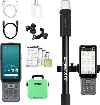
RTK GNSS Survey Equipment with Network RTK Rover, Handheld Controller and Survey Software, GNSS RTK GPS with 60 Tilt and Built-in IMU, for
Item #:
80169174
TZS 4260100
Price Details
Excluding Shipping & Custom charges ( Shipping and custom charges will be calculated on checkout )
*All items will import from US
0 ratings
Write a review
In stock
QTY:
Order now and get it around Saturday, June 27
Secured transaction
Ubuy works hard to protect your security and privacy. Our advanced payment security system ensures confidentiality by encrypting your information during transmission using AES (Advanced Encryption Standards) and SSL (Secure Socket Layer) protocols. Your payment details are 100% secure as we do not share your payment details with third party sellers.
Our Top Logistics Partners
Equipped with advanced IMU tilt functionality, providing up to 60° tilt surveying for higher working efficiency and centimeter positioning in harsh environments.
Fast
Shipping
Free
Return*
Secure Packaging
100% Original Products
PCI DSS Compliance

ISO 27001 Certified
Note: Step Down Voltage Transformer required for using electronics products of US store (110-120). Recommended power converters Buy Now.


What Stands Out
Network RTK Rover
Achieve precise positioning with the integrated network RTK rover, ensuring exceptional accuracy for construction and geodetic applications.
60° Tilt Capability
The 60° tilt feature enhances versatility, allowing users to survey in challenging terrains and tight spaces without compromising data quality.
Built-in IMU
With a built-in IMU, this system provides enhanced stability and reliability, ensuring smooth operation during fieldwork, even in dynamic conditions.
Product Details
| Item Weight | 6 lbs (2.72 kg) |
Who Should Buy?

-
Surveying Professionals
Ideal for land surveyors requiring precision and reliability in geodetic survey data collection and analysis.
-
Construction Teams
Great for construction managers needing accurate layout planning and monitoring of projects with high precision.
-
Geospatial Analysts
Beneficial for analysts working on GIS projects needing detailed positional data with tilt compensation features.

-
Casual Users
Not suitable for individuals who only need basic measurement tools without advanced functionalities or precision.
-
Small Projects
Less ideal for small-scale projects that don’t require high accuracy or complex surveying methodologies.
-
Budget-Conscious Buyers
May not fit those seeking economical solutions, as RTK GNSS technology can be relatively expensive.
Product Description
RTK GNSS Survey Equipment with Network RTK Rover, Handheld Controller and Survey Software, GNSS RTK GPS with 60 Tilt and Built-in IMU, for Construction and Geodetic or Land Survey Layout Planning
Have any Query? Chat with us
Customer Questions & Answers
-
Question:
What is RTK GNSS Survey Equipment and how does it work?
Answer: RTK GNSS Survey Equipment utilizes Real-Time Kinematic (RTK) technology to provide high-accuracy positioning data for surveying applications. It works by using a fixed base station and a rover unit to receive signals from satellites, achieving centimeter-level accuracy. This system is ideal for construction and geodetic surveys where precision is critical, as it minimizes errors caused by atmospheric interference. Professionals in land development can rely on this technology for layout and elevation planning, ensuring projects adhere to regulations and specifications. -
Question:
What are the key components of RTK GNSS Survey Equipment?
Answer: The key components of RTK GNSS Survey Equipment include a base station, a rover GPS unit, a handheld controller, and survey software. The base station is fixed at a known location, while the rover receives RTK corrections and operates over the area being surveyed. The handheld controller typically features a user-friendly interface for data collection and analysis, and specialized survey software enables advanced data management and project planning. Together, these components enhance the efficiency and accuracy of surveying work for professionals in various fields, including construction and land surveying. -
Question:
How accurate is the RTK GNSS Survey Equipment?
Answer: RTK GNSS Survey Equipment provides exceptionally high accuracy, often within centimeters, thanks to its real-time correction capabilities. This precision is crucial for tasks like land surveying, construction layout, and geodetic measurements, where even minor inaccuracies can lead to significant problems in project outcomes. Professionals in fields like civil engineering and topography rely on RTK technology to achieve the exact data necessary for precise angles, distances, and elevations, making it indispensable for effective project management. -
Question:
Is the RTK GNSS Survey Equipment suitable for all surveying types?
Answer: Yes, RTK GNSS Survey Equipment is versatile and suitable for various surveying applications, including geodetic surveys, land surveying, construction layout, and environmental monitoring. Its ability to deliver real-time, high-precision positioning makes it applicable in diverse scenarios, from urban planning to rural land surveys. Professionals frequently use this equipment when working on projects that require detailed topographical maps or accurate boundary data, which supports effective decision-making throughout the project lifecycle. -
Question:
What is a handheld controller and why is it important?
Answer: A handheld controller is a vital component of the RTK GNSS Survey Equipment, providing a portable interface for surveyors to interact with the system. It allows users to collect and analyze data directly in the field, input measurements, and control the rover's operations with ease. The importance of this tool lies in its ability to enhance productivity by consolidating multiple functions into a compact device, enabling surveyors to make real-time decisions and adjustments as they work on-site, thereby improving overall efficiency. -
Question:
How can survey software enhance my surveying experience?
Answer: Survey software associated with RTK GNSS Survey Equipment plays a crucial role in data management, allowing users to process, analyze, and interpret the data collected during surveying activities. It often includes features for creating maps, conducting site analyses, and generating reports. The enhancement comes from streamlined workflows, enabling professionals to visualize their data easily and make informed decisions quickly. For instance, using integrated software can significantly reduce time spent managing data before project deadlines, thereby optimizing overall project execution. -
Question:
Can I use RTK GNSS Survey Equipment for construction projects?
Answer: Absolutely! RTK GNSS Survey Equipment is specifically designed for construction applications where precise layout and measurements are crucial. It assists in site grading, alignment of structures, and monitoring land movement. By providing real-time, high-accuracy location data, it ensures that construction teams execute projects according to engineered plans, reducing rework and enhancing project efficiency. This equipment is especially useful for large-scale developments like highways, where accuracy significantly impacts both the schedule and safety. -
Question:
What type of user would benefit from RTK GNSS Survey Equipment?
Answer: RTK GNSS Survey Equipment benefits a variety of users, including professional land surveyors, construction engineers, and geospatial analysts. The accuracy and efficiency of this equipment appeal to those working in fields that require precise land measurements and mapping. Additionally, professionals in urban planning and environmental sciences utilize it for data collection and analysis, making it a versatile tool across numerous industries. Consequently, anyone engaged in activities requiring detailed spatial information can greatly enhance their processes using this equipment. -
Question:
Where can I buy RTK GNSS Survey Equipment with Rover Handheld GPS?
Answer: You can buy RTK GNSS Survey Equipment with a Rover Handheld GPS at Ubuy, a trusted online retailer. Ubuy offers a wide selection of surveying equipment and ensures a seamless shopping experience. They provide comprehensive product details, making it easier for you to find the right equipment tailored to your construction and geodetic survey needs. Explore their user-friendly platform to discover the best options available for enhancing your surveying projects within Tanzania. -
Question:
What training is required to operate RTK GNSS Survey Equipment?
Answer: Operating RTK GNSS Survey Equipment typically requires minimal training due to its user-friendly interfaces and built-in tutorials. However, some familiarity with GPS technology and surveying practices can be beneficial for effective utilization. Many manufacturers offer training programs or resources that cover operation techniques, data interpretation, and software usage. This training equips users with the skills necessary to maximize the equipment's capabilities, ensuring they can efficiently conduct surveys and make precise measurements in various settings.
SingularXYZ Handheld GPS Units Editorial Review
The Safia One Plus rover has gathered positive reviews from users, with the tilt correction feature being highlighted as a game-changer. Users appreciate the rover's light and small design and its ability to acquire good reception. Some minor inconveniences were noted, such as the need to perform tilt calibration at each boot up and LED indicators that could provide more information on the fix status and battery percentage. Overall, customers were pleased with the performance of the rover. On the other hand, feedback on the data collector was mixed. Users found the hardware impressive, citing features like a bright screen, responsive touch screen, camera shortcut, and good battery life. However, there were concerns about the initial functionality issues with the SIM card and connectivity to the rover, which required a factory reset to resolve. Additionally, the presence of Mobile Device Management (MDM) software on the collector raised privacy concerns for some users. It was mentioned that customer service had to be contacted to disable the MDM software, but root access was not provided. The continuous data connection to mainland China through the survey software was also flagged as a potential privacy issue. Despite the challenges with the data collector, the Safia One Plus rover was commended for its performance when used with NTrip RTK corrections. Users found it suitable for a variety of surveying tasks, including locating ground control points for drone projects and standard boundary and topo surveys. The device was noted for its fast GPS fix, efficient data collection, and the ability to provide sub-centimeter accuracy as advertised. Users appreciated the convenience of not needing a separate base station and the inclusion of the surveying software. Overall, the Safia One Plus rover offers impressive features and performance for surveying tasks, with the added advantage of tilt correction capability. However, potential buyers should be mindful of the data privacy issues associated with the data collector and continuous data connection to mainland China. **
Customer Reviews & Ratings
1 customers ratings
-
5 Star
0%
-
4 Star
100%
-
3 Star
0%
-
2 Star
0%
-
1 Star
0%
Review this product
Share your thoughts with other customers
Pros
- Tilt correction feature is a game-changer
- Lightweight and compact design
- Good reception and fast GPS fix
- Suitable for various surveying tasks without a separate base station
- Sub-centimeter accuracy
Cons
- Privacy concerns related to Mobile Device Management software and continuous data connection to mainland China
Product Price History
Important information
- Limitations : For products shipped internationally, please note that any manufacturer warranty may not be valid; manufacturer service options may not be available; product manuals, instructions, and safety warnings may not be in destination country languages; the products (and accompanying materials) may not be designed in accordance with destination country standards, specifications, and labeling requirements; and the products may not conform to destination country voltage and other electrical standards (requiring use of an adapter or converter if appropriate). The recipient is responsible for assuring that the product can be lawfully imported to the destination country. When ordering from Ubuy or its affiliates, the recipient is the importer of record and must comply with all laws and regulations of the destination country.
- Not all the products listed on Ubuy are for sale, as Ubuy is a global search engine. Products are subject to export/trade regulations.
TZS 4260100
Order now and get it around Saturday, June 27
This item is not restrict in my country.(Please click on above link if this item is not restrict in your country, So our team will review and allow.)
QTY:
Secured transaction
Ubuy works hard to protect your security and privacy. Our advanced payment security system ensures confidentiality by encrypting your information during transmission using AES (Advanced Encryption Standards) and SSL (Secure Socket Layer) protocols. Your payment details are 100% secure as we do not share your payment details with third party sellers.
Our Top Logistics Partners
Fastest cross-border delivery
Features & Benefits
- Advanced IMU tilt functionality for 60° tilt surveying
- Centimeter accuracy in harsh environments
- Pocket-size and lightweight for easy portability
- IP65 protection level and 1.5m drop-proof housing
- Professional surveying software included
- No geo-fence restriction for international use