- Home Page /
- Office Products /
- Office & School Supplies /
- Education & Crafts /
- Geography Materials /
- Maps /
- Missouri State Physical Map - 16.5 x 16.5 Inc...
0 ratings

Item #:
90183912
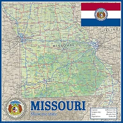
Missouri State Physical Map - 16.5 x 16.5 Inches - Paper Laminated
Item #:
90183912
TZS 104264
Price Details
Excluding Shipping & Custom charges ( Shipping and custom charges will be calculated on checkout )
*All items will import from US
0 ratings
Write a review
In stock
 Imported from USA store
QTY:
Order now and get it around Thursday, July 16
Secured transaction
Ubuy works hard to protect your security and privacy. Our advanced payment security system ensures confidentiality by encrypting your information during transmission using AES (Advanced Encryption Standards) and SSL (Secure Socket Layer) protocols. Your payment details are 100% secure as we do not share your payment details with third party sellers.
Our Top Logistics Partners


Our range of state maps are essential for at-home and classroom learning, plus they look great on any wall!

Fast
Shipping

Free
Return*

Secure Packaging

100% Original Products

PCI DSS Compliance

ISO 27001 Certified


Note: Step Down Voltage Transformer required for using electronics products of US store (110-120). Recommended power converters Buy Now.


What Stands Out
High-Quality Material
Crafted on durable paper with lamination, ensuring longevity and resistance to wear. Ideal for frequent handling and educational use.
Compact Size
At 16.5 x 16.5 inches, it's perfectly sized for both display and portability, making it a great addition to homes, classrooms, or offices.
Detail Rich
Offers intricate details of Missouri's geography, showcasing topographic characteristics that enhance learning and exploration of the region's landscape.
Product Details
| Item Weight | 1 lbs (450 grams) |
Who Should Buy?

-
Educators
Ideal for teaching geography, this map serves as an excellent visual aid for classrooms and educational workshops.
-
Outdoor Enthusiasts
Perfect for hikers or campers, the detailed physical features help navigate and understand Missouri's diverse terrain.
-
Travel Planners
Useful for individuals planning road trips or vacations in Missouri, offering a comprehensive overview of the state's geography.

-
Digital Users
Those who prefer digital maps on devices may find this paper map inconvenient and less accessible.
-
Detail-Oriented Users
Individuals seeking highly detailed maps with extensive topographical information may find this product lacking.
-
Budget-Conscious Buyers
Consumers looking for a more affordable or more comprehensive mapping solution may see this laminated product as overpriced.
Product Description
Missouri State Physical Map - 16.5 x 16.5 Inches - Paper Laminated
Have any Query? Chat with us
Customer Questions & Answers
-
Question:
What are the dimensions of the Missouri State Physical Poster Map?
Answer: The Missouri State Physical Poster Map measures 16.5 x 16.5 inches, providing a compact yet detailed view of the state's geographical features. This size is perfect for classrooms, offices, or personal use, offering an excellent balance between visibility and space. Whether you’re a student learning about the state’s geography, an educator using it as a teaching tool, or an enthusiast wanting to decorate your wall, this map fits seamlessly in various environments. -
Question:
Is the Missouri State Physical Poster Map suitable for educational purposes?
Answer: Yes, the Missouri State Physical Poster Map is an excellent resource for educational purposes. With its clear representation of physical features like rivers, mountains, and landmarks, it aids in geographical studies for students of all ages. Teachers can utilize this map in classrooms to engage students in interactive learning activities or group discussions. It's also a handy reference for field trips or projects focusing on Missouri's geography and ecology. -
Question:
What material is the Missouri State Physical Poster Map made from?
Answer: This map is made from high-quality paper and is laminated, providing durability and a glossy finish that enhances its visual appeal. The lamination not only protects the map from tears and spills but also makes it easy to clean and maintain. This durability ensures that it can be displayed prominently in various settings, from public spaces to personal collections, without worrying about wear and tear. -
Question:
Can I hang the Missouri State Physical Poster Map on a wall?
Answer: Absolutely! The Missouri State Physical Poster Map is designed for easy display on walls. Its standard size of 16.5 x 16.5 inches makes it a convenient fit for most wall spaces. You can use adhesive strips, push pins, or a frame for a more polished look. It serves as an educational piece while also functioning as attractive wall decor, making it perfect for study areas, offices, or living rooms. -
Question:
Are there any notable features highlighted on the Missouri State Physical Poster Map?
Answer: Yes, the Missouri State Physical Poster Map highlights various geographical features, including mountain ranges, rivers, lakes, and notable landmarks. This detailed visual representation can help users understand the topography and terrain of Missouri. Useful for both educational purposes and travel planning, it provides a great overview for those interested in exploring the state's natural beauty or studying its geography. -
Question:
Is the map suitable for professionals in fields like geology or environmental science?
Answer: Definitely! The Missouri State Physical Poster Map is a valuable resource for professionals in geology, environmental science, and related fields. Its detailed physical representation allows for a better understanding of landforms and ecosystems within Missouri. Geologists, planners, and researchers can use this map for identifying geological formations, understanding water resources, or planning ecological studies. It’s particularly useful for presentations and project references. -
Question:
What usability options does the Missouri State Physical Poster Map provide?
Answer: The Missouri State Physical Poster Map offers versatile usability options. It can be used as a reference tool in classrooms, at home for educational enhancement, or as a decorative piece in offices. Additionally, it can support various activities, from geography quizzes to discussions about regional ecology. This flexibility makes it an ideal asset for educators, students, and anyone interested in Missouri's geography. -
Question:
Is this map updated to reflect recent geographical changes?
Answer: The Missouri State Physical Poster Map is created using the latest available data to ensure accuracy in depicting physical geography. Although it captures a snapshot of the current state features, it's advisable to check for the latest updates or developments if you're relying on specific data for professional research. This ensures that users have the most relevant information at hand when discussing or studying Missouri's landscape. -
Question:
Can I use this map outdoors?
Answer: While the Missouri State Physical Poster Map is laminated for durability, it is primarily designed for indoor use. The laminated finish offers some protection against moisture and spills, meaning it can be used in light outdoor environments like patios for events. However, for extensive outdoor use, consider framing or purchasing specialized weather-resistant maps to ensure longevity and preservation. -
Question:
Where can I buy the Missouri State Physical Poster Map in Tanzania?
Answer: You can purchase the Missouri State Physical Poster Map through Ubuy, which offers a wide selection of quality maps and posters. Ubuy provides a convenient platform for shopping, ensuring you have access to this detailed geographical poster right at your fingertips, with various payment and shipping options available.
TigerMoon Maps Editorial Review
No editorial reviews found
Customer Reviews & Ratings
1 customers ratings
-
5 Star
100%
-
4 Star
0%
-
3 Star
0%
-
2 Star
0%
-
1 Star
0%
Review this product
Share your thoughts with other customers
Platform Trust & Buyer Confidence

MT
Mohd
Verified buyer
“The product received very good packaging & safe…Thank You”
16 June 2026 · via Trustpilot
SJ
Shawati
Verified buyer
“Accurate delivery timing given”
16 June 2026 · via Trustpilot
YB
Youcef
Verified buyer
“Not madly expensive like I thought, and much quicker than promised.”
15 June 2026 · via Trustpilot
LM
Leila
Verified buyer
“Never dealt with Ubuy before, but everything worked out great. Seamless cross border purchasing and shipping. Thanks!”
6/7/2026 · via Trustpilot
KA
Kwame
Verified buyer
“The process was smooth, with clear communication and timelines. This was my 1st purchase and I am really impressed. I will definitely be coming back.”
12 June 2026 · via Trustpilot
Secure Checkout
Global Delivery
Easy Returns
Genuine Products
Product Price History
Important information
- Limitations : For products shipped internationally, please note that any manufacturer warranty may not be valid; manufacturer service options may not be available; product manuals, instructions, and safety warnings may not be in destination country languages; the products (and accompanying materials) may not be designed in accordance with destination country standards, specifications, and labeling requirements; and the products may not conform to destination country voltage and other electrical standards (requiring use of an adapter or converter if appropriate). The recipient is responsible for assuring that the product can be lawfully imported to the destination country. When ordering from Ubuy or its affiliates, the recipient is the importer of record and must comply with all laws and regulations of the destination country.
- Not all the products listed on Ubuy are for sale, as Ubuy is a global search engine. Products are subject to export/trade regulations.
TZS 104264
Order now and get it around Thursday, July 16
This item is not restrict in my country.(Please click on above link if this item is not restrict in your country, So our team will review and allow.)
QTY:
Secured transaction
PCI DSS compliant and ISO 27001:2022 certified, with encrypted payments and full buyer protection on every order.
Our Top Logistics Partners
Fastest cross-border delivery
Features & Benefits
- Essential for home and classroom learning.
- High-quality, durable laminated poster.
- Provides detailed information on key cities, parks, and bodies of water.
- Perfect for planning road trips or exploring new areas.
- Visually appealing, ideal for wall decoration.
- Educational and informative with easy-to-read fonts.
Ubuy Assurance
Experience worry-free shopping with 100% original products, PCI DSS-compliant payment security, ISO 27001-certified data protection, the fastest cross-border delivery, free returns *, and secure packaging on every order.