- Home Page /
- Office Products /
- Office & School Supplies /
- Education & Crafts /
- Geography Materials /
- Maps /
- World Map Classic Style - Front Sheet Laminat...
0 ratings


Item #:
9787463
World Map Classic Style - Front Sheet Lamination - Cartographic Detail (A0 33 (h) x 47 (w) inches)
87% of respondents would recommend this to a friend
Item #:
9787463
TZS 122185
Price Details
Excluding Shipping & Custom charges ( Shipping and custom charges will be calculated on checkout )
*All items will import from US
0 ratings
Write a review
In stock
 Imported from USA store
QTY:
Order now and get it around Thursday, September 03
Secured transaction
Ubuy works hard to protect your security and privacy. Our advanced payment security system ensures confidentiality by encrypting your information during transmission using AES (Advanced Encryption Standards) and SSL (Secure Socket Layer) protocols. Your payment details are 100% secure as we do not share your payment details with third party sellers.
Our Top Logistics Partners


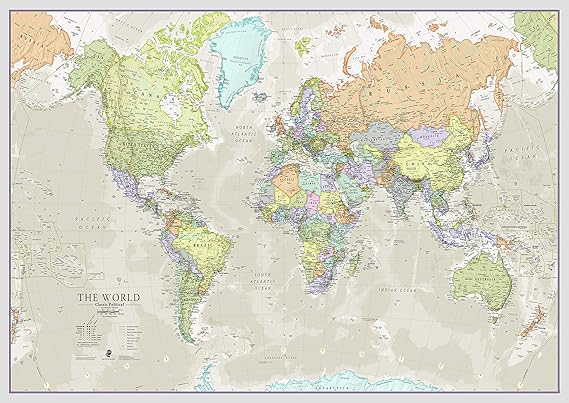
The large world map poster features every country in a different color with hill shading and time zones.

Fast
Shipping

Free
Return*

Secure Packaging

100% Original Products

PCI DSS Compliance

ISO 27001 Certified





Note: Step Down Voltage Transformer required for using electronics products of US store (110-120). Recommended power converters Buy Now.


What Stands Out
Classic Aesthetic
This world map combines traditional cartographic detail with a classic style, making it a timeless decor piece suitable for any setting, enhancing the visual appeal of homes or offices.
Durable Lamination
Front sheet lamination ensures long-lasting durability and protection against wear and tear, allowing the map to maintain its pristine appearance while being easy to clean and maintain over time.
Large Format
Measuring 33 x 47 inches, this map provides expansive visibility, making it perfect for educational settings, presentations, or as a standout wall art piece that inspires curiosity and adventure.
Product Details
| Package Weight | 10.41 Pound |
Who Should Buy?

-
Educational Use
Perfect for classrooms, this map provides detailed information and is an excellent learning tool for geography lessons.
-
Home Decor
Aesthetic choice for living rooms or offices, it adds a classic touch while serving as a conversation starter.
-
Travel Planning
Ideal for travel enthusiasts, it helps in visualizing destinations and planning adventurous trips around the globe.

-
Budget Buyers
Individuals looking for inexpensive decor might find this premium-quality map out of their budget range.
Product Description
World Map Classic Style - Front Sheet Lamination - Cartographic Detail (A0 33 (h) x 47 (w) inches)
Have any Query? Chat with us
Customer Questions & Answers
-
Question:
What are the dimensions of the Maps International Giant World Map?
Answer: The Maps International Giant World Map measures 46 inches in height and 77.5 inches in width. This substantial size makes it an impressive statement piece for your wall, perfect for educational environments, offices, or personal spaces. Its expansive dimensions allow for clear visibility of details, making it easier to study geographical features or plan travels. -
Question:
Is the Maps International Giant World Map laminated?
Answer: Yes, the Maps International Giant World Map comes laminated, which adds durability and protection against wear and tear. This feature ensures that the map can withstand frequent handling, making it ideal for classrooms or family rooms. The laminate also allows for easy wiping, enabling the removal of smudges or other marks, keeping your map looking pristine for years to come. -
Question:
What design style does the Classic Large World Map feature?
Answer: The Classic Large World Map features a traditional design that incorporates rich colors and detailed cartographic information. This style not only appeals to geography enthusiasts but also complements various interior decor themes, from vintage to modern. It serves as both a functional educational tool and an artistic piece for home or office display. -
Question:
Can I use the Maps International Giant World Map for educational purposes?
Answer: Absolutely! The Maps International Giant World Map is an excellent resource for educational settings. Teachers can use it to teach students about different countries, continents, and geographical features. Its large size makes it suitable for group discussions and presentations, helping to visualize world geography effectively. -
Question:
Is the map suitable for children’s rooms?
Answer: Yes, this world map is suitable for children’s rooms, providing an engaging and educational decoration. It can inspire curiosity about different cultures, countries, and geography. Displaying it in a child’s space can encourage learning through exploration, making it an excellent tool for parents who want to enrich their child's environment. -
Question:
What is the best way to mount the Maps International Giant World Map on a wall?
Answer: The best way to mount the Maps International Giant World Map is to use adhesive poster strips or mounting boards to ensure a flat, secure fit on the wall. If you prefer a more permanent solution, framing the map can enhance its visual appeal while providing additional protection. Consider positioning the map at eye level for optimal viewing. -
Question:
Does the map include political boundaries and names?
Answer: Yes, the Maps International Giant World Map includes detailed political boundaries and country names. This information is vital for educational purposes and can help individuals understand Tanzania geography better. The clear labels and borders make it easy for viewers to identify different nations and their locations. -
Question:
What environments are suitable for displaying this world map?
Answer: The Maps International Giant World Map is versatile and can be displayed in various environments, including offices, classrooms, libraries, or even living rooms. Its large scale makes it ideal for communal spaces where multiple viewers can appreciate and learn from it. It can also be a conversation starter in social settings. -
Question:
How can I clean the laminated surface of the map?
Answer: Cleaning the laminated surface of the Maps International Giant World Map is simple. Use a damp cloth with mild detergent to wipe away dirt and smudges, ensuring you dry it afterwards to prevent moisture buildup. This maintenance keeps the map looking vibrant and enhances its longevity, making it a durable choice for long-term use. -
Question:
Where can I buy the Maps International Giant World Map in Tanzania?
Answer: You can purchase the Maps International Giant World Map at Ubuy, an online platform that offers a wide selection of products, including world maps. Ubuy provides a convenient shopping experience and fast access to this classic large world map poster, making it easy for customers in Tanzania to enhance their spaces with this educational tool.
Maps International Maps Editorial Review
The Maps International Giant World Map is a classic, large world map measuring 46 inches high by 77.5 inches wide. The map is laminated, making it easy to clean and durable. The watercolor design is muted, and the map provides a lot of definition and information, making it an excellent educational tool. It is up to date and designed and made in the UK. It is a large poster that can be mounted on the wall using double-sided tape. Framing is possible, but it would require a large frame. Customer
Customer Reviews & Ratings
1 customers ratings
-
5 Star
100%
-
4 Star
0%
-
3 Star
0%
-
2 Star
0%
-
1 Star
0%
Review this product
Share your thoughts with other customers
Pros
- Large size
- Educational tool
- High-quality product
- Durable and easy to clean
- Can be drawn on with dry erase markers Customer
Cons
- Shiny surface causes glare
Platform Trust & Buyer Confidence

MA
Mohammad
Verified buyer
“Excellent quality and original too,when ubuy send original things I will appreciate that ,I very satisfied thank you”
23 July 2026 · via Trustpilot
CK
Chitra
Verified buyer
“The order and delivery progress was communicated very well. Package arrived within the estimated time. Products arrived as expected in good condition.”
22-Jul-26 · via Trustpilot
K
kund
Verified buyer
“Good supply of products. Safe payment methods, and shipment worldwide! Genuine products.”
23-Jul-26 · via Trustpilot
OO
Onesi
Verified buyer
“Was my first time buying a product from Ubuy, but I found it so helpful. This is reliable. Gonna place a new order!”
22 July 2026 · via Trustpilot
SJ
SAO JOHN
Verified buyer
“Ubuy is a great online platform to buy stuff. Reliable, fast delivery time and great value for money. I've been using Ubuy online shopping platform for three years now and will continue to do so.”
23 July 2026 · via Trustpilot
Secure Checkout
Global Delivery
Easy Returns
Genuine Products
Product Price History
Important information
- Limitations : For products shipped internationally, please note that any manufacturer warranty may not be valid; manufacturer service options may not be available; product manuals, instructions, and safety warnings may not be in destination country languages; the products (and accompanying materials) may not be designed in accordance with destination country standards, specifications, and labeling requirements; and the products may not conform to destination country voltage and other electrical standards (requiring use of an adapter or converter if appropriate). The recipient is responsible for assuring that the product can be lawfully imported to the destination country. When ordering from Ubuy or its affiliates, the recipient is the importer of record and must comply with all laws and regulations of the destination country.
- Not all the products listed on Ubuy are for sale, as Ubuy is a global search engine. Products are subject to export/trade regulations.
TZS 122185
Order now and get it around Thursday, September 03
This item is not restrict in my country.(Please click on above link if this item is not restrict in your country, So our team will review and allow.)
QTY:
Secured transaction
PCI DSS compliant and ISO 27001:2022 certified, with encrypted payments and full buyer protection on every order.
Our Top Logistics Partners
Fastest cross-border delivery
Features & Benefits
- Political map of the world with cartographic detail
- Classic tones suitable for any home decor
- Write-on finish for use as a classroom map
- Crease-free delivery in a tube
- Map created by expert cartographers at Maps International
- Map measures 33 (h) x 47 (w) inches
Ubuy Assurance
Experience worry-free shopping with 100% original products, PCI DSS-compliant payment security, ISO 27001-certified data protection, the fastest cross-border delivery, free returns *, and secure packaging on every order.